Desert Oysters
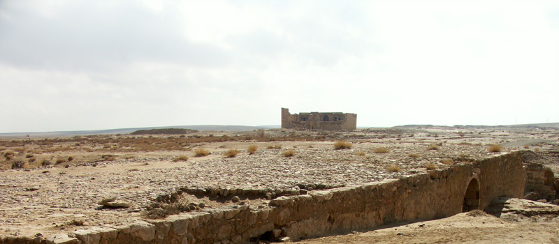
Al Hisa is a small town on the desert highway about half the way between Amman and Aqaba. The modern town has nothing to offer for visitors, as its traditional houses were completely replaced by “contemporary” concrete buildings, completely lacking any planning or charm. The location of Al Hisa, nevertheless, remains important, as a historic stopping point of the road to Mecca. This importance is demonstrated by the caravanserai of Al Hisa (also called Qal'at Al Hisa) and a railway station on the Hijaz Railroad. Nowadays the fame of this town can be best attributed to the phosphate extraction activities in the badland to the east.
So rich are the phosphate deposits next to this town that geologists gave its name to a type of rock layer (Al Hisa Phosphorite Formation) –a layer which extends to under many parts of Jordan and as far as Irbid. Although the phosphate deposits give economic opportunities to the people of Al Hisa, the mining operations pollute their environment, scarring their beautiful desert landscape with heaps of unsafe and unsightly earth materials dumped all over the place.
If you hold a chunk of phosphate in your hands, you easily detect countless bits of bones in all shapes and sizes, usually white and soft, and often held together by a grayish matrix. The story of the phosphate deposits at Al Hisa is connected with the impressive layers of fossil-rich limestone. These layers, or bands of rocks, represent some of the sedimentary limits of the phosphate and often contain better preserved fossils, less fragmented and in a harder state.
From these layers comes the so-called “Bahiyya Coquina”, a national treasure. The name Bahiyya comes from a wadi to the east of Al Hisa and “coquina” is the term geologists use to describe a type of limestone composed almost entirely of shell fragments.
The mountain range to the north of Al Hisa Castle appears uninteresting from a distance. You can drive up to the rolling hilltops from different points. On the way up there are cliffs with overhanging rims, and the shade-drenched layer beneath has a peculiar texture. On stopping the car and walking for closer inspection, you find that the entire cliff is built of compacted shells. The composition and matrix appears almost edible, like a blown-up version of some of those muesli or sesame bars with complete grainy parts pressed together in a medium of transparent sweet syrup.
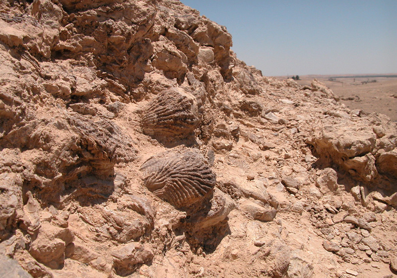
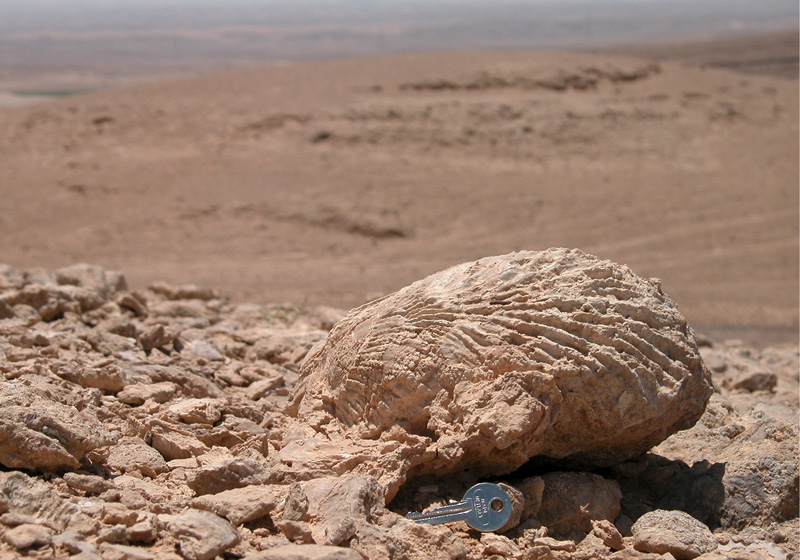
As the car climbs further up you notice you are driving on shells that stick out of the rock matrix, giving the rubber wheels an excellent grip. On top of some of these hills, the oyster layer happens to correspond with the erosion level, giving complete individual oysters the chance to break loose. Here, oysters, as large as honey dew melons, rest in their Campanian- Maestrichtian beach deposits (around 70 million years old) and have detached themselves from their location for the first time since. You walk on this amazing oyster bank, and if you pick one up, you are moving it from its 70-million-year location for the first time since this fossil bed was still living. While many of the shells are still in their closed position, some are split, giving you their jagged oyster smile.
The age of these oysters is strongly connected to that of the phosphate deposits. The oyster bank itself seems to have played a role in the deposition mechanics of the phosphate. It has been noticed that such oyster ridges are found as boundaries of phosphate layers. The general explanation is that these oyster banks, in Al Hisa, 1-18 meters high, were separating the deep water of the Tethys Ocean to the north, from a sub-tidal to a shallow shelf environment to their south. Geologists explain that such oyster reefs were working as an underwater dam that deposited the phosphate behind it (to the south) –phosphate, which was brought up from the depth of the Tethys by currents of cooler water.
The way we look at the geology of this little town might need to be reconsidered. Slowly but surely, Jordan should think of moving away from the direct exploitation of geological features through mining, and more towards higher levels of economic activities based on informative and interpretive services. There might be a need to evolve from the economy of extraction to the economy of services, or even an economy based on developing meaningful experience-destination within its natural heritage. In this direction, we may move away from an economy with hidden environmental bills, and towards one that is more symbiotic with our rich landscape.
Al Hisa is a full day destination. Drive on the desert highway for about 140km till the town of Al Hisa. At the beginning of the town, before the bridge, exit between the houses and head west to the empty land behind. This drive brings you to Al Hisa Fort, which should be visible in the wadi few kilometers further west. From the first part of the road, take the first most used dirt road to the north. From this location, there are many little paths that take you up to the higher parts of the line of hills clearly visible as a northern edge of the Hisa basin. For the drive on the hills a 4x4 is definitely needed. Make sure you have a sun hat and some water. For those with a GPS, mark N= 30 50.072 / E= 35 58.188 for one of the best locations of big oysters.