Via Nova
It is amazing how little-changed remain some parts of the Jordanian landscape since the Roman times. It could be said that for the last 2000 years, 90% of the change happened during the last 50 years. This has given us the unique chance to have the last glimpse of a long era, before it is gone forever.
We might think that the most impressive remains that the Romans left us are sites like Jerash, Roman Amman, and other Decapolis cities. But one must also remember the less picturesque infrastructure that the Romans have left; namely water systems and roads. Somehow, because Jordanian archaeology is increasingly tourism driven –unfortunately, forces of the marketplace are reducing our history to photogenic sites, to carvings and ornaments on architectural monuments, and to tourists’ attractions as conceived by tour operators. Jordan is missing presenting the bigger picture, in which its history can be understood and presented, to its people and visitors alike, in a way that is more story-centered rather than site-centered.
In a way the Roman road-system that runs on the longest line of Jordan, from few kilometers east of the Jaber Syria crossing and all the way to Aqaba, might be considered the largest of archaeological remains in the kingdom. It would also mean that this monument, or the substantial segments left of it, would be the most clearly visible archaeological feature in Jordan –as seen from a satellite.
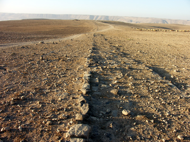
Unlike structures with standing walls, the Roman road has survived earthquakes better, as it was built of stones paved flat on the landscape, and in level areas it has nothing that can collapse. It is, on the other hand, fragile, for not being clearly recognized and respected by people or by public decision makers.
The Via Nova Trajana was completed in 114 AD, by Emperor Trajan, to link Roman provincial Capital of Bosra with Ayla on the Red Sea. It might have, of course, overlapped, connected and crossed older roads. It is clear that this road was the result of an official project to construct a “Roman Highway” with a system of milestones that were part of a comprehensive engineering endeavor. One could estimate the length of the main Via Nova, from the Syrian borders to Aqaba, to have been at least 400 kilometers long.
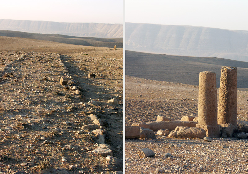
Besides some of the good stretches of this road that are still traceable on the landscape east of the Shobak castle, or on the southern slopes of Wadi Mujib, the extensive segments in the area around the village of Baa’ij are the most impressive. One can in fact trace this road all the way from Khirbet Al Samra -10km north of Zarqa- and drive by it northwards for tens of kilometers, till the villages to the east of Mafraq.
From the village of Baa’ij, one of the locals accompanied me on a drive by the side of this road, till we had to stop when the well-preserved Roman road actually crossed the borders and continued into Syria. Within a group of four or five villages, you can notice that the road is following a straight line to Bosra, it enters one village where it becomes the main paved street and exits again heading to the next one.
In one location I saw some milestones at the entrance of a house, I first had this feeling of disapproval for what is often a bad habit of people gathering these inscribed pillars as relics from the past, thus removing them from their original location. But looking carefully I found that I was wrong –it was a pleasant surprise to discover that the milestone pillars were actually in their original location, and that the road actually passes along the front of the front garden of the house. In this stretch of the Via Nova, we are lucky that the modern paved road is laid next to the antiquities and on top of it, and, hopefully, future road widening will take place with recognition to this important historic monument.
In most of the well-preserved segment of the Via Nova in this area, you can see an interesting feature; there is a clearly distinguishable widening addition to the east of the road. Did this addition take place decades or centuries later, or was it the widening that Trajan added to an older road, or was the first Roman contractor replaced because the road was too narrow?
The Via Nova is a monument that can show us how to explain our history in a more innovative way. It is a monument that connects other monuments, providing us with a story-line, and a chance to re-think our archaeology in a manner that can benefit our children’s understanding of the past, as well as that of tourists; provided we would still have some meaningful stretches of it left after few years.
Take the highway to Damascus, drive until Mafraq, then ask for directions to the village of Baa’ij, about 10km east-east-north of Mafraq. This is one of the best spots to find the Roman road. You can also ask the locals about the Roman road “Al Tareeq Al Roumāni". There are a dozen or so villages in this area, all within a few kilometers drive, and all have something worth seeing. This destination to explore the Roman road can be conveniently combined with a visit to the impressive site of Um Al Jimal, Um Masrab, and other Roman-Byzantine sites in the vicinity. If you don’t have time for preparing sandwiches at home, you can always find a bakery at these villages, and almost any of their small shops would have yogurt, sardines, or other good ideas for a quick bite. It is always more exiting if you research the site you are planning to visit before making the field trip. There are numerous resources that mention the “Via Nova Trajana”. You can also try a Google search on the Internet. This destination needs minimum half a day, while a full day is better if you like to explore the area at your ease.