Jawa - the Dawn of Water Engineering
To the east of Mafraq and before Safawi, hides a surprise: the landscape rises as high as 1160 meter above sea level, giving this corner of Jordan a different feel of greener ground cover, cooler temperatures and dramatic features unexpected to be found in the eastern desert.
It makes it easier to understand the height of this land if one sees it as the southern slope of Jabal al Druze (also called Jabal al Arab) further to the north in Syria. The high elevation in the midst of the eastern desert gives drastic changes in the climate, and few kilometers to the north, inside Syria, some natural stretches of oak trees can be found in total paradox with their wider context.
Jabal al Druze, and its continuation into Jordan, is the centre of the volcanic landscape of Harret al sham. This geological feature should be connected to most of the archaeological remains in northeast Jordan. It should also be connected to the oasis of Azraq, as Jabal al Druze provides a kind of water-harvesting and water-retaining device in the otherwise harshly arid land.
Understanding the bigger picture, especially its hydraulic aspects, it might be easier to grasp the location and peculiar architecture of the site of Jawa. As the northeastern desert is nowadays rather arid, it must have been much greener before, when grazing was less destructive, and wild life more abundant. The location of Jawa, at the mouth of Wadi Rajil, is ideal. It benefits from the highland to the northeast, with water running down from the wetter hills, and it benefits from the flatter desert to the south and the east, with abundant mudflats and warmer winters.
Archeologically speaking, Jawa remains a riddle on an international scale. Its fame is centered on the water system that is, so far, the world’s most ancient, well researched and documented series of dams from around 3000 BC. Water canals, some as long as 8 kilometers were built to direct water into a system of reservoirs that had impressive storage capacities. Gravity dams at Jawa have utilized walls designed against the dangers of water-backpressure, a precautionary solution that was reinvented only in recent modern engineering.
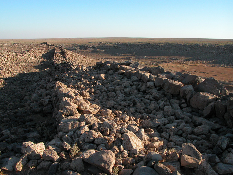
The dams of Jawa used to provide a walled city of about 2,000 inhabitants. The settlement occupies a hillside with defensive architecture that used two layers of defense, each provided by a massive parameter wall as thick as 3 meters. These walls divided the city into two parts, a lower neighborhood and an upper one, both resulting in a kind of double-tiered “citadel”.
The architecture of Jawa houses shows how construction was accomplished with large natural blocks of basalt without any tool-marks. Slabs of basalt were used to build outer walls, piled up as central pillars, and spanned as roof-slabs. Archaeologists have also found some mud bricks used in construction as well as oak rafters and joists brought some 5000 years ago from the near-by forests of Jabal al Druze.
This large settlement, with its defensive, nucleated, complex architecture, still presents archaeologists with the most difficult questions. What is also a conundrum is the short lifespan of this site’s first extensive occupation (during the forth millennium BC) that might have lasted only for one generation.
The gravity dams of Jawa occupy the central story in any textbook on the history of dams. Jawa is definitely the most important and most surprising archaeological site, in Jordan and in the world, in regard to the history of the development of large-scale water projects. With all the appropriate scholarly attention that this site has got, it is unfortunate that the ancient water structures were partially ruined due to physical intervention a few years ago. The cement additions that were built and failed to collect water, should have never been permitted. The situation at Jawa is a typical example of “official vandalism”. To avoid destroying whatever is left of Jordan’s unique history, we owe Jawa an investigation into the wrong planning –a proper conduct of public inquiry might set a good precedence in this regard.
Jawa is about 25km north-north-east of Safawi. The lack of a paved road has actually helped to protect this very important site, and at the same time this destination is easily reachable through moderate off-road driving. The most dramatic approach to the site is to arrive from the northwest. A paved road brings you to the village of Dair al Qin, where a sign of Jawa points to the general direction east of the village, from that point you have to find your destination through dirt roads. Jawa needs a guide who knows the area. You can also ask some of the locals to help you find it. It is also important to mention that this site is only few kilometers away from the borders with Syria, which gives another reason not to get too lost in the surroundings. Jawa with the basalt villages to the west is a full-day destination. It can be combined with Um el Jimal, Dair al Kahf, or Um Masrab. This destination can also be visited in half a day, especially for those who have been there before and know the way. This is an excellent picnic destination, relaxing, and very exiting if you enjoy ancient history and open landscape.