Little Fort
A small dusty town on the Desert Highway, Qataraneh is the most favorite stopping point for travelers heading south. From the first glance, the choice of this location for settlement seems to have been for no specific reason. However, viewing the place in more depth, one can notice that Qataraneh’s location is generally greener than the rest of the surrounding desert.
Indeed, Qataraneh can be seen as an oasis. Although in a typical oasis groundwater usually rises till it appears above surface, in Qataraneh the underground water-table was high enough to allow some trees to gather at this spot since a long time in the past. The high water-table also encouraged, during the second half of the 20th century, the digging of many wells that were also equipped with pumping facilities. Qataraneh is a point of abundant water on the edge of the desert.
Besides the underground water, Qataraneh’s location has another hydraulic feature to offer: the efficient water-gathering wadis that pass through its land. Both the underground water, which might have been accessed by historic wells, and the surface water available in winter, are important to understand the attraction of the original site. While the underground water can supply the inhabitants or travelers with water almost all year round, the water level might drop dramatically by the end of summer. By then water would permeate into deeper aquifers, feeding springs on lower points located mostly towards the west, in side-wadis feeding the bigger valleys leading to the Great Rift. By the end of summer –sometimes as early as October– when rainfall revives the desert, the underground water would be at its lowest position. This is the time when water is most difficult to get, and the gathering of early surface-water greatly helps.
The fort of Qataraneh took advantage of this water situation, which depends on two systems complementing each other. Beside security, the more pressing water availability was a crucial need for people crossing this landscape, and forts such as this provided both. Such structures were built in a line between Damascus and Mecca to provide resting points for seasonal pilgrims as well as other travelers around the year. All of these forts, (I know of at least 8 between Amman and the Saudi border-crossing at Mudawwara) have some geomorphology-inspired solutions for secure water –mostly pools, gathering water from wadis running nearby.
One should view water pools as part of the wider context. They are actually connected to a much larger system that includes wadis, collecting dams, diversion channels (open, vaulted, or on aqueducts) and special small pools for filtering silt and stones. It might be a good idea to think that these pools are more important than the forts. One should imagine the efforts involved in construction, and remember that there must have been some carefully calculated decisions for such hard toil to pay back. This could also mean that the history of exploiting water-collecting possibilities in any of the forts’ sites often pre-dated the fort.
There are some problems in giving exclusive dates to these caravanserais. Although their structures are mostly dated as Ottoman, their location, as well as their more important water systems might date to pre-Ottoman periods.
It would be interesting to excavate behind the walls of the pool next to the Qataraneh fort, as the backfill might contain some pottery of Islamic, Byzantine, or even Roman or Nabataean periods. There might also be older walls, or remains of older water canals that belong to different times. It should be stressed, nevertheless, that a site such as the Qataraneh fort was not necessarily able to gather the stratified layering of a typical settled site of a village or city, for this was a transit spot, with minimal number of permanent residents, and maybe it was completely desolate for decades or even for centuries.
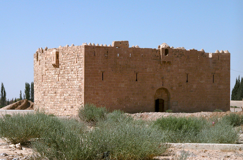
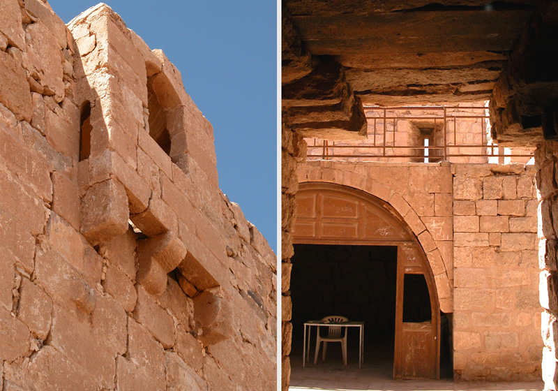
The Qataraneh fort is a charming little place, a forgotten caravanserai on the pilgrimage route. The current structure, mostly dated to the mid-sixteenth-century and built under Sultan Suleiman the Magnificent, is now in rather good condition. It must have functioned as a small bed-and-breakfast, a lodge where people found security for their heavy loads and for themselves, resting behind the closed main door with their camels and goods on the ground floor, and a modest half-star guestroom above.
The line of forts, with its water pools, was so well established in the remote past, that the planning of the Hijaz Railway had no other choice but to strictly follow. The Hijaz Railway, constructed during the first decade of the 20th century, was not the last to make use of these resting points, today the Desert Highway passes along the very line, giving us resting points at many spots where our ancestors used to stop.
The drive to Qataraneh becomes an easy, relaxing drive the minute you pass the last traffic light on the Airport Road. Qataraneh is ideal for a half-day outing. It is also perfect for a lazy late-Friday-morning drive, possibly in combination with a visit to the impressive site of Umm Al Rasas. You can also enjoy a short visit to the fort on your way to other destinations in the south such as Petra, Dana, Wadi Rum or Aqaba. The fort is so close to the main Desert Highway that it only requires little extra time. The direction to Qataraneh fort is straight forward: The structure is clearly visible west of the Desert Highway, at the southern end of the town, just before the Karak exit. If you are not curious to discover some other hidden sites, away from the paved roads, there is no need for a 4x4 for this destination.